Tarbert life is a project of Tarbert & Skipness Community Trust to help people understand and enjoy the story of our village. For more information on Tarbert & Skipness Community Trust please visit our website on www.tsct.org.uk.

If you’re ready, jump in and immerse yourself in Tarbert Life!
Welcome to the online home of Tarbert Life. Here you can enjoy stepping into the past and discovering more about Tarbert’s royal roots, follow the generations of fishermen who hunted for the silver darlings, the herring which made Tarbert famous and join us as we take you on a journey to meet some of the characters who made up village life.
As you will appreciate, covering so much, our history, heritage and life in Tarbert today is going to take time. Our new website is a work in progress, but we hope you’ll join us on this journey and keep coming back to see what’s new!
Yes, we have rich history which we’re very proud of, but we have so much to offer. While fishing remains at the heart of the village, new industries have emerged. The castle is no longer a stronghold for kings, but it is a magnet for historians and tourists alike. And with festivals and celebrations playing a huge part in our calendar you’re assured of a warm welcome.
However, some things never change. Fishing is still an integral part of village life, the Castle still overlooks the village, our young people attend both primary and secondary school in Tarbert and we still have ‘sea bathers’ although we call them wild swimmers now.
Tarbert became a royal burgh after 1329. Close to the castle would have been a small settlement and church but very little is known about how it evolved. Future excavations at the castle might shine a light on Tarbert’s early history.
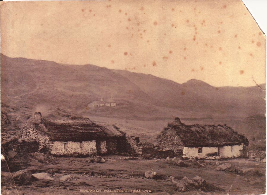
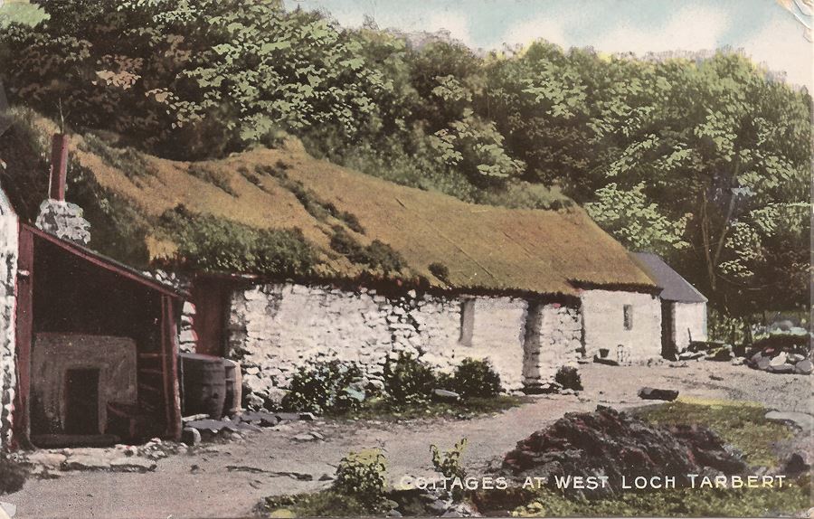
By the 18th century a small village had developed to the west of the castle. Documents suggest that this was a simple row of thatched cottages with earth floors (along what is now known locally as Back Street)
with other cottages scattered on the outskirts and across the hillside.


Thatched cottages on Church Street (Back Street) with the parish church on the hill to the rear 1903
In 1775 a church was built, on the location of the present Church of Scotland and, there was a court house. Reverend Alexander Campbell in the First Statistical Account (1794) described the biggest challenges in the parish being the lack of proper schools, the scarcity of fuel, the state of the roads, high rents, disease and emigration.
It is no exaggeration to say that fishing has played some part in the history of every family who can trace their roots through the village.
From the men who have fished Loch Fyne and beyond, to the fisher lassies waiting on the quay for the boats to return. To the people who worked in the fish factories and smokeries to the newest generation of fishermen – the village owes you a debt of thanks.
Let us take you on a trip through our fishing history.
The Silver Darlings
Herring made Tarbert famous. Known as the Silver Darling, it had long been a staple food due to its taste and ease of preservation by curing.
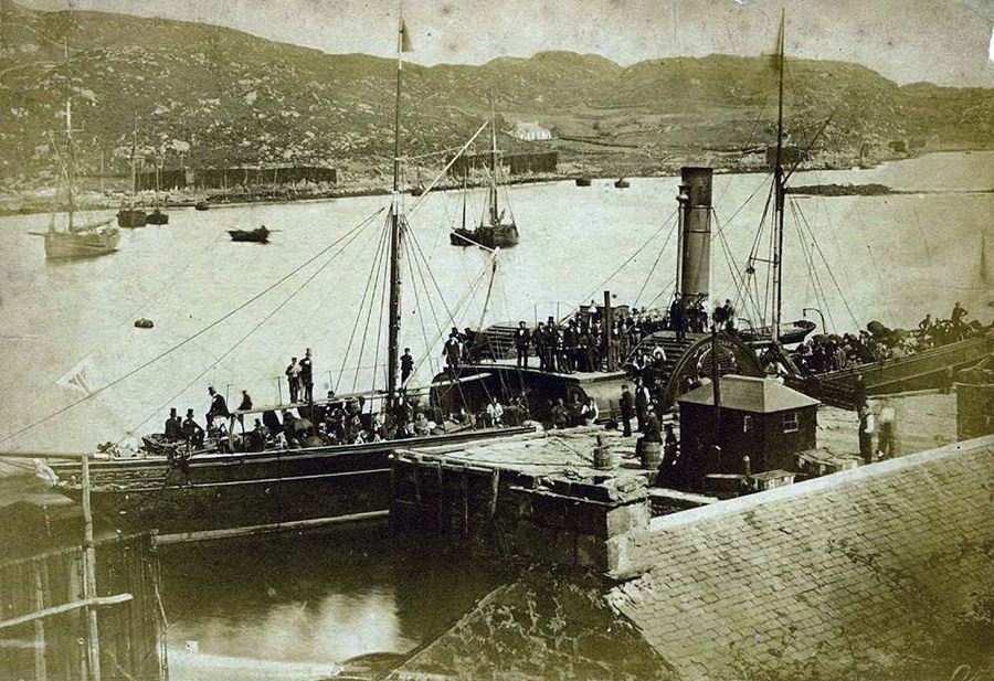
The shoals thronged Loch Fyne and the heyday of this fishing spanned a century starting in the 1850’s. The little skiffs with their rakish masts
and brown sails would fish the loch from June to January and then follow the shoals north to the Minch or south to the Ballantrae Banks to their
spawning grounds.
Ring Net Fishing
The herring were originally fished using a drift net but Tarbert men pioneered a much more efficient method using two boats and a ring net to
encircle the glistening shoals. Like all revolutionary methods it was both lucrative and controversial and a huge outcry from the drift net
fishermen led to the ring net being declared illegal. For 16 years fish wars raged on the waters of Loch Fyne. The Tarbert fleet were in the
thick of it, often clashing with the naval gunboats Jackal and Porcupine which had been sent to police the legislation by seizing nets and gear
from offenders. In 1867 the ring net men triumphed and trawling with your ’neebor’ boat and a ring net became legal.

Catherine Anne and Maireared breasted up while pairing for herring.
Barking was the process used to help preserve
cotton nets and sails which otherwise would quickly
deteriorate.
Drift nets needed constant attention and
maintenance. Until the introduction of synthetic fibre
nets in the 1950s, fishermen spent a lot of time
barking, drying and preserving their nets.
The barking of nets was done by immersing them in
a hot preservative substance made principally from
the bark of native oak and birch trees. From the
middle of the 19th century ‘cutch’ from countries
such as India and Borneo was used, one of the
earliest examples of cheap imports replacing locally
produced products.
Cutch was made from
acacia or mangrove trees
by stripping the bark from
the trees and boiling it in
water. The thickened
extract was decanted
into iron pots and boiled
again until it attained a
syrupy consistency. It
was then poured into
moulds and exposed to
the sun and air until it
hardened into a dark
brown substance. This is
why all the old sails were
a tan colour.
The barking of the nets
was carried out in large
cauldrons heated by a
fire underneath. Nets were usually barked at the start of the summer and
regularly every few weeks during the fishing season
to prevent damage or decay to the twine or the
ropes of the nets.
The nets were barked in Leitch the Sailmaker’s
premises on Garvel Road. They were taken ashore
at the old Barking House Quay just below Leitch’s
and manhandled up the path into tanks on the
ground floor.
Drying the nets after use was equally important to
avoid decay. They were dried on rails attached to
tall poles (croichs) set into the shore on all sides of
the harbour.

Lined by shops, cafés, hotels and restaurants, the harbour is the hub of the village.
Whether you live and work in Tarbert or are visiting, it’s impossible not to notice our glorious gateway to Loch Fyne.
The small inlet of Loch Fyne, known as East Loch Tarbert, forms a natural harbour. Used for shelter, fishing and trade for over a thousand years, it is undoubtedly the main factor in Tarbert’s existence.
In the 1320s Robert the Bruce arrived for his periodic sojourns in ‘the King's Great Ship’. The Exchequer Roll for 1328 records a fee of 7 shillings and eight pence for the making of a ’coket’ (a customs seal) for Tarbert to impose a levy on goods despatched through the port. Over a century later James IV provisioned Tarbert's Castle with guns and ammunition.

Having overlooked Tarbert for centuries, Tarbert Castle has seen and heard it all. The castle is the enduring heart of the village and it is a ‘must see’ destination on your visit to Tarbert.
Tarbert’s Royal Castle is built in a strategic location on a narrow isthmus only a mile wide between East and West Lochs Tarbert at the north end of the Kintyre peninsula.
In earlier times it is likely that a small hill fort existed on the high ground above the sheltered anchorage. The Annals of Ulster mention the burning of a fort at Tarbert in 712 and again in 731.
By sea Tarbert is only 40 miles from the River Clyde and 30 miles to the Ayrshire Coast in sheltered water. Across the isthmus, Tarbert is only 30 miles from the Inner Hebridean Islands.
These links by water enabled sailors to avoid the arduous journey around the dangerous Mull of Kintyre, a sea route with strong tidal streams and a rocky shoreline. Even today this is considered a challenging route for sailing small boats.
Goods would have been traded and boats hauled across the shortcut for many centuries, including during the Viking period as told in the Norse Legend, The Orkneyinga Saga
King Robert the Bruce hauled his own Birlins across this thin strip of land in the later Medieval period on his way to the islands of the Inner Hebrides when ‘portage’ over the isthmus would still have been common practice.

Tarbert Map
Strategic Location
A brief look at a map of Scotland’s Southern West coast in the twenty-first century might make the observer wonder why a large Royal Castle should be located a hundred miles by road from the country’s biggest city, in a relatively under populated rural area.
Tarbert’s Royal Castle, is built overlooking a narrow isthmus between East and West Lochs Tarbert, at the northern end of the Kintyre peninsula.
Tarbert derives its name from the Gaelic compounding of tarruing, to draw, and bata, meaning boat. The variations of spelling are numerous. In the oldest records it is Tarbart, then Tarbard. Later it is spelt as Terbert, Tarbert, Tarbett, Tarbet, Tarbatt, Tarbat, Torban, Tarbot, Tarbitt, Terbat, Turbet and Terbart. No date of its foundation can be traced.
By sea Tarbert is only 40 miles from the river Clyde and 30 miles to the Ayrshire coast, in sheltered water. Across the isthmus Tarbert is only 30 miles by sea from the inner Hebridean islands.
These links by water avoided the arduous journey around the dangerous Mull of Kintyre, a sea route with strong tidal streams and a rocky shoreline. Even today this is considered dangerous water for sailing small boats
Earlier Times
In earlier times it is almost certain that a hill fort existed on the high ground above the sheltered anchorage.
Goods would have been traded and boats hauled across the shortcut for many centuries, including during the Viking period, as told in the Orkneyinga Saga.

Early Thatched Cottages

Early Thatched Cottages
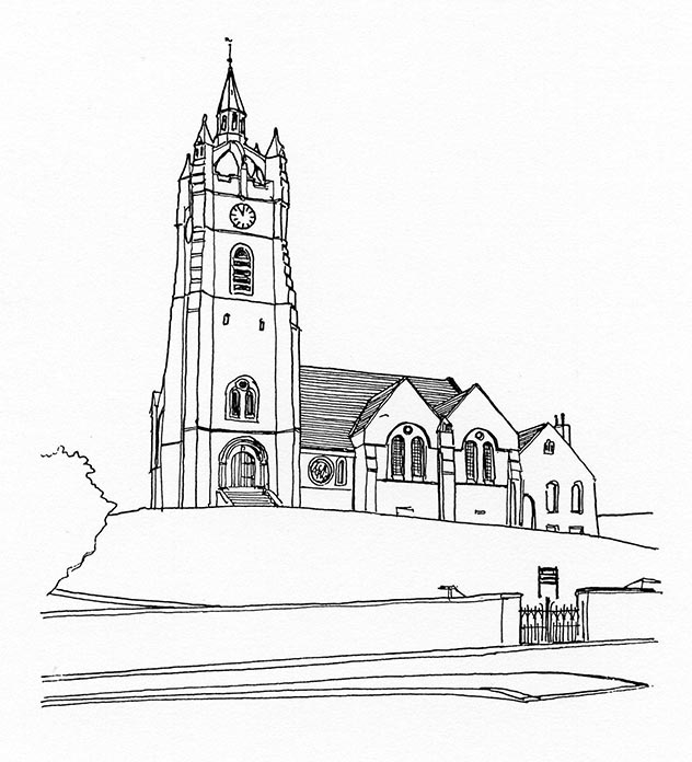
Tarbert Parish Church
The Minister of the parish of Kilcalmonell records
that a Royal Bounty Mission Station had been
established at Tarbert in 1775. The first minister of
the mission was the Rev. John Smith, who went on
to become minister of the church in Campbeltown.
In 1837, Rev. Colin Fisher Campbell set down the
earliest description so far found of the Tarbert
Church, with an estimated building cost of £500. The
church was enlarged in 1842, but it was not until
1864 that full parish status was granted. By 1885 the
enlarged church of 1842 was dilapidated, and
unable to cope with the needs of the growing
community of Tarbert.
In August 1885 demolition began and work
commenced on the construction of a new church, at
a cost of £3,000 to seat 600 persons.
The main feature of the church, situated behind the
harbour, is its square tower which rises over 100
feet from the ground surmounted by an unusual
crown and lantern structure.
The clock,
manufactured by
Gillet and Co. of
Croydon, was
gifted to the
parishioners and
Kirk Session of
Tarbert Parish by
James Elder
McLarty.
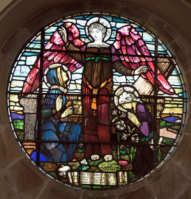
The church has
a small stainedglass window
designed by
Harrington Mann, a member of the Glasgow Boys
movement in the 1880s.
The church roof interior features striking colour
decoration, with the lower part painted in a series of
pillared arches and a myriad of coloured starry
patterns above adorning the wooden ceiling. This is
presumed to be the work of the architects of the
church, Messrs J ,McKissock and W. G. Rowan of
Glasgow.


Illustration of Tarbert Parish Church
© Scottish Churches Trust

Tarbert Parish church before the construction of the new tower
Marine Life
Tarbert’s inhabitants have access to two different seas: the Firth of Clyde and the Atlantic. Both are protected from the worst of the
winter gales by the Kintyre peninsula and a variety of islands varying in size from Islay to tiny skerries.
Tarbert harbour opens out
into the East Loch, an inlet
of Loch Fyne, itself an arm
of the Firth of Clyde. Loch
Fyne was deeply gouged
out by glaciers and is over
100m. deep in places, with
big tides. Check out the
interpretation board at
Garval Road car park and
the Earra Gael to see
descriptions of the various
bird species you are likely to see.
Seaweed and Plankton
If you look in the harbour at any state of the tide, you’ll
see plenty of seaweed. Seaweed is a valuable food
source for many animals including humans and is rich in
minerals and vitamins. The base of the food chain,
seaweed and plankton produce 70% of the world’s
oxygen.
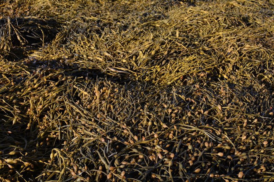
Kelp – the largest of our seaweeds – grows profusely on
our rocky shores below the low-tide mark. It is one of
the fastest growing organisms on earth and can grow
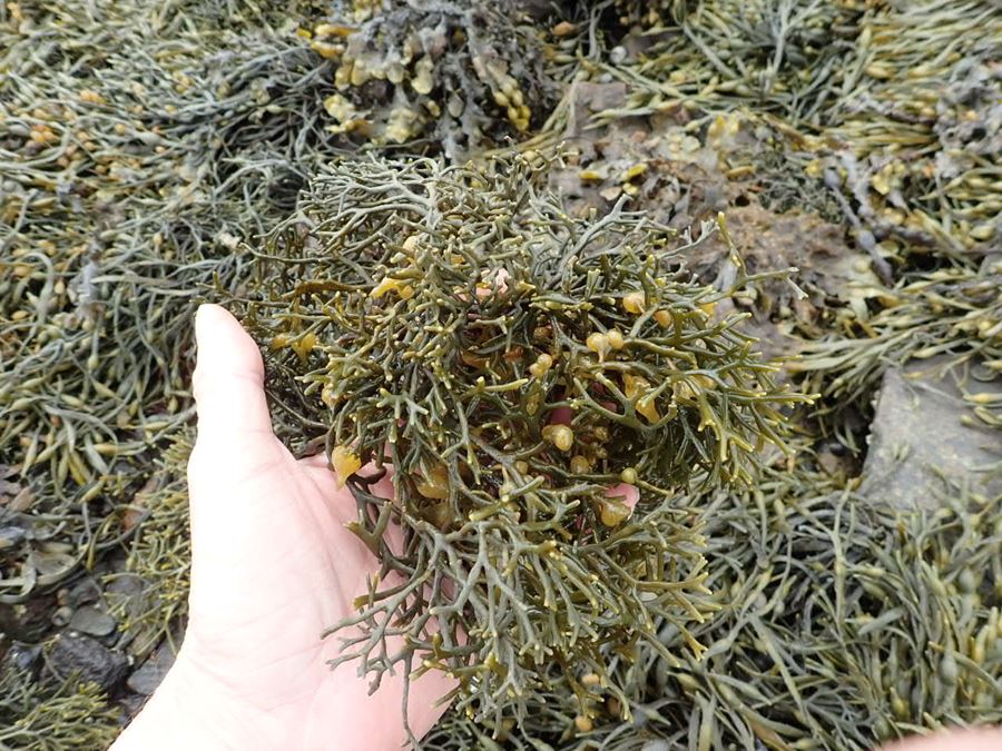
5cms a day. Tarbert Harbour is also home to wig wrack,
a rare species in Argyll. You can see this at the Co-op
end of the harbour.
The reason our seawater appears green rather than
blue is because of the presence of plankton: a vast
array of tiny creatures including algae, diatoms, jellyfish
and the larval forms of many marine species, indeed
any living thing that depends on the currents to get
about

Crofters Wig © Owen Paisley

Egg Wrack and Bladder Wrack © Ed Tyler